Archive for August, 2012

ALMOST THERE

Checking in from Van Nuys, Los Angeles, CA …

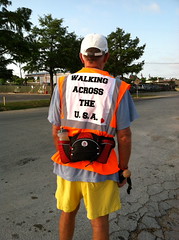
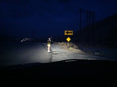
Over the last two days, I walked from Pasadena through Los Felix and Hollywood to Beverly Hills ending just some 7.5 miles short of the finish line of this fantastic journey. That last leg will take place on Sunday, September 2, ending at the Santa Monica Pier. Some members of our family and some of our friends will either walk with me or be at the finish line to celebrate with Brenda and me. Many others, who have been with us in spirit, will be in our thoughts as the final of an estimated 5.6 million steps are completed.

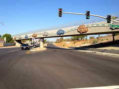
A press release from the LA American Heart Association (AHA) had invited the media to meet with me in Pasadena at the Colorado Street Bridge. This is a beautiful 99 year old concrete arch bridge that spans Arroyo Seco and connects Pasadena to the towns of Eagle Rock and Glendale. It is on the National Historic Register and is beloved for its Beaux Arts arches, light standards and railings. Locals know it with the unfortunate moniker of the “Suicide Bridge” since almost 100 people have jumped from this structure over the years.

We were delighted that four television stations and one newspaper were there to cover and help promote my walk for heart health. (No, they didn’t come to see me jump from the bridge.) The ABC, NBC and Fox affiliates were represented and filmed interviews as did the Los Angeles local station, KDLA. The local newspaper, the Pasadena Star-News also sent a photographer and conducted a telephone interview. The media coverage gets our message out and helps explain the need for exercise to mitigate the risks of heart disease. It can also help encourage donations to the AHA through our website. Thanks to Kristine Kelly of the Los Angeles AHA for a great job arranging the media event.

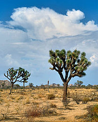
The Los Felix area borders Griffith Park, a 4,310 acre municipal park that is a favorite of Angelinos. Much of the park was donated to the city in the late 1890’s by mining tycoon Griffith J. Griffith. He had owned the land for years where he had attempted to breed and raise ostriches. When ostrich plumes for ladies hats fell out of favor, he deeded the land to the city to avoid property taxes and promote adjacent land that he was developing for housing. 
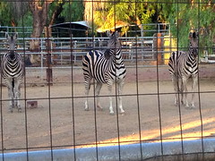
The deed specified that the park must include an observatory, a planetarium, amphitheater and boys and girls camp. The park today includes all that plus the LA Zoo, horseback riding and hiking trails, numerous picnic areas, a golf course, the Greek Theatre and my favorite, the Gene Autry Western Heritage Museum. Countless films and television shows have been filmed in Griffith Park. As an aside, Mr. Griffith was a colorful character who later served time in prison for shooting and nearly killing his wife.

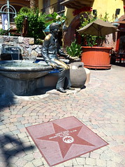
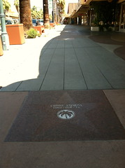
Much of the walk through Hollywood treads on the Stars Walk of Fame. There 2,476 of these stars planted in the Hollywood sidewalks, literally everyone I could imagine from the film world, TV, radio and music. I found the star for Gabby Hayes but missed Hopalong Cassidy’s. I also got a taste of the other Hollywood when I had to skirt my way around two winos involved in a shouting, pushing battle in an apparent turf war. Every cuss word I have ever heard, plus a few new ones, were being screamed. As I scurried away, the police were on the way.

We had heard on the radio that California and Hollywood in particular was a haven for potheads with marijuana legal for most any ailment, real or imaginary. On a whim and not because we were interested personally, we asked SIRI on my I-Phone for how many “medicinal marijuana” shops were in Hollywood. She replied that there were 36 “cannabis clinics” within a three mile radius with names like The Honey Spot, Mr. Greenjeans Collective, The Gourmet Green Room, 99 High Collective, Hollyweed Caregiver and The Fountain of Well Being. The freaky sideshow in Hollywood now makes sense.

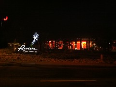
Traveling west on Santa Monica Blvd, I was humming Sheryl Crow’s “All I Want to Do Is Have Some Fun (‘till the sun comes up on Santa Monica Blvd)”. The path got progressively better as I moved into Beverly Hills–attractive boutiques and bistros; beautiful houses and estates; upscale in almost every way. It’s easy to understand why this is home to the stars.

Sunday, the walk moves on to the beach. Time to celebrate and think about this once-in-a-lifetime journey. Time to thank Brenda for her unflinching partnership on this trek. Time to thank so many others for so much encouragement and support. Time to remember that it is not the destination, but the journey that counts. We’ve seen a great country and met wonderful people. Hopefully, we’ve touched a few lives. We are gratified by those who have said that Heart Trek USA has inspired them to start an exercise program. We’ve fallen short so far of our fund raising goal for the AHA but are so grateful for those who have contributed. Thanks to all our supporters.

Thanks to Walt Mancini (Pasadena Star-News); eecue.com and greyism.com for their great their pics.

Read Full Post »

TOURISTS IN LA

Checking in from Van Nuys, CA …

  With some down days in Los Angeles, Brenda and I have played tourist in the Los Angeles area.  Much of it was a refresher as we have visited LA several times in the past.  The area is still busy as can be, with lots of road construction, unbelievable traffic and really aggressive drivers.  You have to blend in and drive like a crazy person just to keep from getting run over.  But there is so much to see if you can only get there.
  From the RV park in the Van Nuys section of metro LA, we headed down to scout routes through the city for the final legs of the walk.  On the way to the center of the city, we passed the magnificent J. Paul Getty Museum high on a hill above the 405 (Interstate 405).  It is now rated as the number one attraction in the area, no small feat.  We hope to visit the Getty with friends and family on Saturday, the day before the end of the walk.

  We rode by our headquarters hotel on the edge of Beverly Hills and scouted several possible routes down to Santa Monica.  Since others may choose to walk all or part of the final leg with me, we wanted a safe and scenic route.  We settled on a walk down Olympic Blvd and Colorado Ave, a distance of roughly 7.5 miles.  We couldn’t resist diverting briefly down a cross street, Rodeo Drive, to see how the other half lives.    Lots of people were strolling down this thoroughfare, but not many were carrying shopping bags.  The stores were all the famous, high end names with lots of bling available at a price.  One store under construction, Bvlgari the Italian Jeweler, caught our eye.  The cars on the street included Ferrari, Maserati, Bentley and for the commoners Mercedes, Lexus and BMW.  And then there was our red Honda Element.

  Not far from Beverly Hills down Sunset Blvd and Hollywood Blvd, we headed into Hollywood proper, passing by the Gateway to Hollywood structure (commonly known as the Four Ladies Statue) with the four corner posts representing the multi-ethnicity of movie’s leading ladies with likenesses of Mae West, Dorothy Dandridge, Anna Mae Wong and Delores Del Rio.  First stop was Grauman’s Chinese Theatre and the Stars Walk of Fame.  Couldn’t held remembering Lucy and Ethel stealing John Wayne’s cement hand and boot prints.  We certainly weren’t the only ones seeking this famed tourist spot.  Tourists were thick, mixed with locals dressed in costume garb and hawkers luring people to shops, restaurants and tour buses.    The area has upgraded considerably since our last visit with lots of new buildings and attractions.  One modern building, the Hollywood Highland Center, is designed to frame the trademark Hollywood sign on a hillside in the distance.  Even some of the old holdovers have been really spruced up, most notably the El Capitan Theatre operated by Disney and continually showing classic Disney animated films—“Cinderella” today.

  Trying to get a better view of the Hollywood sign, we headed up into the hills toward the Griffith Observatory.  Didn’t get very close, however, as the parking lot was full and both sides of the road were crammed with cars for more than a mile in both directions.  So we returned the next day when the Observatory itself was closed.  The view was spectacular in all directions and with a smaller crowd and a half full parking lot, we were able to visualize the scenes that were shot here for James Dean’s “Rebel without a Cause.”

Three more days of walk ahead—Pasadena to Beverly Hills to Santa Monica.  Been a long and memorable journey.  Thanks for being with us in spirit on Heart Trek USA.

Read Full Post »

INSPIRATION

Checking in from Pomona, CA …

Continuing on the historic route of old Route 66, I have passed endless small towns that run into one another and make up part of the greater Los Angeles area—San Bernardino, Rialto, Fontana, Rancho Cucamongo, Upland, Claremont, La Verne, Pomona, San Dimas, Glendora, Azusa, Duarte, Monrovia, Arcadia, East Pasadena and Pasadena so far. Each town has its own character–some upscale, some downscale, some attractive, some not, some well maintained, some not—but all are interesting as part of the mosaic that our journey has revealed.

As many of you have seen from our photos, I walk with a bright orange or yellow vest (provided by our friend Jo Ann Stockwell) for safety and to promote my walk with the emblazoned message “Walking Across the USA.” The vests have often been our best promotional tool, causing many passersby to stop me and ask about my journey and wish me well. The message doesn’t get through to everyone, however. On many occasions and three times in the last two days, people have stopped me to ask directions. Maybe it’s just me, but I’d assume that someone walking across the country probably is not a local boy.

While walking through San Dimas and Glendora, I got a couple of e-mail messages from a guy who had been following my journey via our website and had passed me earlier in the day while taking his daughter to school. Dan Crowther was very interested in my trip, said I had inspired him and wanted to meet me. He tracked me down near the end of my walk and shared his story with me. Dan’s father, Tim, was a Glendora policeman who worked with the youth of the area. In 1996 at age 48, Tim died suddenly of a heart attack. He was so beloved in the community that a new teen and youth center was named after him. Tim’s family was obviously crushed by his passing, but Dan took the loss to heart. He took up an active exercise program, and with his wife Janna, has now run five marathons and is training for a sixth while raising funds to help fight cystic fibrosis.

I was impressed by Dan’s positive reaction to a tragic loss and his dedication to exercise to help overcome obvious genetic heart disease risk. I also could not help noting that I was 48 years old in 1996, had suffered a heart attack but had been blessed to have survived. Tim Crowther had obviously touched many lives and had left a wonderful legacy. My trek suddenly seemed a little less significant. While Dan felt that I had inspired him, I was instead the one who was moved and inspired. After my walk, Brenda and I visited the Tim Crowther Teen and Family Center and felt privileged to be there. Dan had also given me a gift that I will wear proudly on the rest of walk and even afterward—a small pin replica of Tim Crowder’s police badge. Thank you Dan and thanks to the memory of your father, for putting my efforts in perspective and for inspiring me to continue to spread the word about improving cardiovascular health.

I passed some landmarks on my latest walk. The Santa Anita Park in Arcadia is the most famous horseracing track in the west and is home to both the Santa Anita Derby and the California Derby. Winners of these races usually go on as three year olds to run in the Triple Crown races. The Rose Bowl in Pasadena is a shrine to football fiends like me. It’s the “Granddaddy of ‘Em All,” the first and still most important bowl game. We also rode by the Tournament of Roses Parade Headquarters which is housed in the former mansion home of William Wrigley, the chewing gum tycoon. Brenda and I had been fortunate to have helped decorate a Rose Bowl Parade float some years ago and loved the experience. We hope to participate again in a year or two.

At the end of my walk in Pasadena, Brenda and I were met by old friends. Lillian and Dennis Mah are the parents of our daughter-in-law Debbie, and Helen Wong is Debbie’s aunt. We have stayed in touch with these folks since our son Jeff’s marriage to Debbie some thirteen years ago and have always enjoyed visiting with them. They plan to walk with me some as we pass near their home in Eagle Rock and will be with us at the end of the walk to celebrate. We enjoyed a very nice lunch with Lillian, Dennis and Helen and had fun sharing stories of our trip.

I have just three days of walking left on this journey. To accommodate the LA media, I will take a few days off and walk from Pasadena through Glendale and on to Beverly Hills early next week. Then friends and family will join me as I walk the final leg to the Santa Monica Pier on Sunday, September 2. Brenda and I will play tourist in the days in between. If we see anything interesting, we’ll continue to share the descriptions and photos with you on our website and on Facebook.

Read Full Post »

HISTORIC ROUTE 66

Checking in from Pomona, CA …

On our last semi-rural leg of this walk across America, my path took me through the San Timoteo Canyon of Riverside County. The canyon winds between well worn hills and is dotted with orange groves and horse farms and equine training facilities. The orange trees were full of smallish juice oranges and the ground was littered with the fruit. We could not understand why the fruit was not being harvested on a timely basis. We saw many beautiful horses and several young girls being trained to post and ride. One farm had some strange striped equines (see photo).

After visiting the attractive town of Redlands, I walked into the town of Loma Linda and could tell that my entire remaining track would be through a suburban or urban environment even though I was still at least 80 miles from Los Angeles proper. Before long, I was walking on San Bernardino Blvd and then Foothill Blvd. These two roads are part of the Historic Route 66 which was one of America’s major highways before the Interstate Highway system. Route 66 was officially known as the Will Rogers Highway, and it ran from Chicago to LA, a distance of 2,451 miles. Unofficially, the highway was known as the “Main Street of America” and the “Mother Road.” Oldsters will remember the television series “Route 66” with Martin Milner (as Todd Stiles) and George Maharis (as Buzz Murdock) finding adventure on the road in their Corvette convertible.

On the San Bernardino part of the road, we found the original McDonald’s Restaurant, the first Mickey D’s. In 1940, brothers Dick and Mac McDonald opened McDonald’s Barbeque Restaurant which offered an extensive menu and 25 very attractive female carhops. It quickly became the number one teen hangout in the area. The restaurant was profitable, but teens tended to hang-out and reduce turnover. As World War II was ending, Dick McDonald saw the baby boom coming and wanted to attract young families. He also studied his sales and found that hamburgers constituted 80% of the volume. So in late 1948, the McDonald brothers took a huge risk and closed their successful restaurant, terminated the carhops and reduced their menu to hamburgers, cheeseburgers, French fries, milkshakes and soft drinks. Reorganizing their kitchen to accommodate the simple menu, the new McDonald’s counted on faster service and lower prices. Today the original restaurant is a museum (no food) where you can see the original Ronald McDonald statue and the golden arches as well as advertisements, caps, shirts, pics, menus, straws and cups that were used back in the 50’s.

In 1954, a milkshake machine salesman named Ray Kroc joined the restaurant as a franchise agent to try to duplicate the concept. The McDonald brothers wanted to proceed slowly while Kroc had visions of a nationwide and perhaps worldwide chain. Frustrated with the pace of growth, Kroc hocked everything and with borrowed funds bought the franchise in 1961 from the McDonald’s brothers for $2.7 million. The rest is history.

Much of the current portion of Route 66 is somewhat rundown and a little dated. The portion through Rancho Cucamonga is an exception, however, and is very upscale and affluent. Bordered by Mount Baldy, this town, which means “a sandy place” in the native Indian language, got its start in the 1840’s as a vineyard area when water runoff was diverted from the mountain range. One restaurant, the Sycamore Inn, was opened in Rancho Cucamonga in 1848 and continues to serve prime beef to this day.

We got a real treat on Sunday evening when Brenda’s cousin, Tripp Doepner, and his family invited us to join them for dinner at the historic and beautiful Mission Inn in Riverside. Both Tripp and his wife, Gincy, are educators, and Gincy is an accomplished organist. It was our first time meeting Gincy and the Doepner’s two daughters, Mary Travis and Dabney Margaret. These two young ladies (ages 13 and 10) proved to be very smart and interesting. Mary Travis is a finalist in the National Science Fair, and Dabney Margaret works diligently on Franklin Graham’s Operation Christmas Child Project. After assembling over 70 shoebox gifts last year, she is aiming to prepare 100 boxes for needy children this holiday season.

The Mission Inn is truly spectacular both in its architecture and the precious art that is everywhere throughout the facility. The Inn is a combination hotel, restaurant, museum, arts center and National Historic Landmark. Opening in 1903 and owing its original elegance to the cultural insight and business genius of Frank Augustus Miller, the Inn pays tribute to California’s early Spanish and Mexican heritage with a quirky inclusion of a remarkable collection of Oriental artifacts and architectural touches. While the Inn fell into disrepair following Miller’s death, it has been restored and enhanced in recent years through the foresight and generosity of Riverside businessman Duane R. Roberts.

The main lobby features a massive carpet showing all of California’s original missions, and the priceless artworks include Tiffany stained glass and a magnificent carving called “The Mandarin’s Journey.” In our opinion and in its own way, the Mission Inn rivals the elegance of the Biltmore House that we have visited on several occasions. We thoroughly enjoyed our time at the Mission Inn and the chance to visit with Tripp and his wonderful family.

Even though there are 13 days left before I walk onto the Santa Monica Pier, I have less than 60 miles remaining on this fantastic journey. Since we have friends and family coming to share the end of my walk, I’ll stage my walks over four or five more days and then take some down time as Brenda and I visit the Los Angeles attractions. But I will continue to exercise on a regular basis and will then celebrate as the final leg of Heart Trek USA is completed on September 2. Thanks to everyone for your support.

Read Full Post »

Checking in from Redlands, CA …


 On my last couple of days in the desert, I came through the Morongo Valley to an area known as the San Gorgonio Pass.  This opening through the mountains is just west of Palm Springs and is bisected by Interstate Highway 10.  The pass is reputed to be the windiest place in all of Southern California.  To take advantage of the breeze that can be stiff at times, the pass is home to an awesome sight—a wind farm comprised of a whopping 3,218 wind turbines.  These turbines look similar to huge airplane propellers, each mounted on 160 foot high towers.  We had seen wind towers in other parts of the Southwest, but never in such massive numbers.  With each turbine generating approximately 615 megawatts of power, the wind farm provides most of the electricity for the desert cities.


 I am not allowed to walk on interstate highways (and really do not want to).  Between Palm Springs and the towns of Banning and Beaumont, however, I-10 is basically the only highway.  To navigate through this area, I had to take on some really rough terrain on what amounted to little more than ATV trails right through the wind farm and straight up a mountain, though admittedly one of the smaller ones.  Thought I was in good shape, but I was huffing and puffing when I reached the summit after having stumbled through the thick gravelly sand studded with rocks and boulders.  The down slope was not much better, but it ended in a pretty area where the rapids of the Whitewater River cut through the boulders.


 After crossing the Whitwater Canyon River, I reached my stopping point for the day.  As Brenda and I were discussing my route for the next day, a Riverside County Sheriff’s car pulled up.  Sergeant Higgins offered advice since the track would still be challenging for the next day or so.  He advised a slight change of path to avoid walking through the Morongo Indian Reservation where the sheriff’s department had no authority and where there was a chance that I might experience some trouble.  We appreciated his concern and followed his advice.  The police across the US have been universally helpful and supportive.


Next towns on our path are Redlands, Loma Linda and Rialto where I’ll walk on Foothills Blvd which tracks part of the old Route 66.

Read Full Post »

PALM SPRINGS, CA

Checking in from Palm Springs, CA …

For our last few days in the Mojave Desert, we planned to move to an RV park in the famed desert oasis of Palm Springs. We had to be careful in choosing a park since in this area there are some gay only parks, clothing optional parks and parks for those 55 years of age and older. We were really afraid we might inadvertently end up in a park that met all three of these criteria. Thankfully, however, we found a straight, clothed and all age park.

Being well ahead of schedule, a down day in Palm Springs was planned. It came a little earlier than scheduled, however, when our car battery died at 5:00AM as we preparing to head out to my walk. By the time AAA arrived with a new battery, it was too hot and too late to walk that day. So, we used the day to explore the area. Just wish we would have known and not gotten up at 4:00AM.

I’ve heard of Palm Springs all of my life as the desert playground for Hollywood’s superstars. From the 1920’s on, this green gem on the edge of the unforgiving desert has attracted celebrities based on the legendary “two hour rule” of the movie studios which required actors under contract to be available within two hours in case a last minute reshoot had to be made. I think they cheated a little on the time and distance since Palm Springs is about two and half hours from Hollywood even with the Interstate highways of today. Who knows how long it took in the 20’s?

The list of names who called Palm Springs home is pretty impressive especially for old folks like me—Bob Hope, Bing Crosby, Frank Sinatra, Dean Martin, Cary Grant, Kirk Douglas, Jack Benny, Gene Autry and Albert Einstein just to name a few. Frequent visitors have included Marilyn Monroe, Elizabeth Taylor, Dinah Shore, Clark Gable, Ava Gardner, Lucy and Desi, Elvis and Priscilla (who honeymooned here), Mickey Rooney, Dwight and Mamie Eisenhower, Ronald and Nancy Reagan and many more. With the introduction several years ago of the annual Palm Springs International Film Festival by then-mayor Sonny Bono, Hollywood has rediscovered the town. Currently, the area attracts such stars as Clint Eastwood, John Travolta, Ron Howard, Halle Barry, Leonard DiCaprio and Anne Hathaway.

The town is beautiful, though hot at this time of year, with a distinctive art deco look. As an example, the centerpiece of the town is a 30 foot high statue of Marilyn Monroe in an iconic pose. There are lots of upscale shops, boutiques and restaurants. The town is clean and well laid out with lots of green space and countless palm trees. The area is definitely affluent, especially the neighboring community of Rancho Mirage where the main shopping street, El Paseo, looks like Rodeo Drive and homes can cost up to $8 million. Golf courses are numerous, and the area has been the home to PGA and LPGA events like the Bob Hope Chrysler Classic and the Dinah Shore Desert Classic. Palm Springs recognizes its allure with streets named after Frank and Bob and Dinah and Kirk and Gene. A walk of fame, much like in Hollywood, with stars imbedded in the sidewalk graces the downtown district. Art is important with statutes throughout the town, many of which incorporate motion. My favorite, however, is a bronze of the Singing Cowboy, Gene Autry, but then my heroes have always been cowboys.

While the shops are much too expensive for the likes of Brenda and me, we do spurge in this heat on our favorite cooling treat, frozen yogurt. In Palm Springs, we found Eddie’s Frozen Yogurt which has been selected as “Best of the Best.” This is a single, non-franchise shop run by our new friend, Eddie Carrasco. His yogurt is really good, and Eddie’s friendly and welcoming demeanor makes you want to come back (which we did). Eddie’s Frozen Yogurt is a must stop if visiting Palm Springs and be sure to “like” his FB page, “Eddie’s Frozen Yogurt”.

Next stops on my trip are the towns of Banning and Beaumont. Less than three weeks to the Santa Monica Pier.

Read Full Post »

Checking in from Palm Springs, CA …

Well, we are close to finishing our trek across the Mojave Desert. We’ve enjoyed the sights and the beauty, but we are ready for this part of the trip to end. Just too hot! Maybe at another time of the year. I’ve managed on my walks by starting at 5:30AM and ending by 10:00AM. I’ve basically stopped when the temperature topped 100 degrees. But then we’ve had to endure the afternoon in the oven that our RV can be. When temps hit 115+ degrees, there is no way the air conditioning can keep up. The inside walls of the RV are actually hot to the touch. From 3:00PM to 7:00PM, there just is no relief.

We’ve spent several nights in the military town of TwentyNine Palms with a large military base nearby, the Marine Corps Air Ground Combat Center. The base is home to the 7th Marine Regiment, 1st Tank Battalion, 3rd Combat Engineers, 11th Marines and 3rd Assault Amphibian Division. Leathernecks from this base led the assault and fall of Baghdad in Operation Iraqi Freedom. As would be expected, the town has its share of tattoo shops and massage parlors. What we didn’t expect, however, were the number of barber shops. Must have been seven or eight offering marine cuts, combat cuts, even stud cuts. I’ve felt like a long hair in this town.

Twentynine Palms got its name from the trees that were there when the town was formed in the 1850s by Mormons fleeing persecution on what came to be known as the Utah Trail. There are many more palm trees there now, and the town has decorated its buildings with really nice murals on many walls that trace the history of the area. In fact, Twentynine Palms now bills itself as an “Oasis of Murals.”

Just outside town, there is a large dry lake bed known as the Dale Dry Lake. It is startlingly white and is actually a salt flat that has been mined for its salt for years. On the lake bed, Brenda discovered a meticulously laid-out message made of football size boulders. Covering at least 100 yards in length, the message was obviously intended for aircraft flying over the area. The message read “The Bottom of the Ocean of Air.” We don’t know the source of the stone message but understand that it refers to atmospheric layer that surrounds the earth.

This part of the desert borders the Joshua Tree National Park, and the next town after Twentynine Palms is named Joshua Tree. The referenced tree is very unique and native to only this area. It has a distinctive look with its branches or arms reaching to the sky. The Mormons named the tree after Joshua who raised his arms to the heavens and asked for God’s guidance before the Battle of Jericho.

Next town on the trip is Yucca Valley and then Palm Springs, where we’ll take a down day to enjoy this desert oasis.

Read Full Post »

MOJAVE DESERT

Checking in from Twenty-Nine Palms, California …

Over halfway across the desert. Beautiful, changing terrain but hot as can be. Sunrises are really special, and we see most of them in an attempt to get in four hours of walking before the temps hit triple digits. From mile to mile and sometimes right across the road, the vista varies as the gravelly sand and stunted desert vegetation meets the many mountains and hills that dot the landscape. No gradual run-up, the basically flat desert floor ends abruptly at the foot of the mountains that seem to have popped right up through the sand. Some are rounded and smooth; others are sharp and jagged; still others look like piles of huge boulders. And some appear to be composed of sandstone while others are granite and some are obviously lava mounds.

The Mojave is a tough environment. No wonder it is mostly uninhabited by man. It is a fragile eco system, however, where even slight changes in seasonal temperatures and rainfall threaten the stubborn vegetation and animal life. This desert is best left as untouched as possible with very few roads, no towns and only the relatively non-intrusive Colorado River Aqueduct crossing the area. The aqueduct, running from Lake Havasu, is partially above ground, partially underground. It is the primary water supply for the metro areas of Southern California.

We did, however, leave behind a couple of modest marks of our time in the Mojave. Rice, CA became noted for its “Shoe Fence”, a lone tamarisk on a turnout just south of the highway. For reasons unknown, it became customary for travelers on Highway 62 (also known as Rice Road) to and from the Colorado River to hang a pair of old shoes on the fence. On the “shoe fence” I retired a pair of worn-out Asics shoes and hung them along with hundreds of others that travelers had left behind. No one seems to know when this phenomenon started, but now a piece of Heart Trek USA will remain long after we have moved on. Then at another empty crossroad called Iron Mountain Pumping Station Road and Hwy 62, Brenda added two directional signs to a long standing totem pole showing the distance to our hometown of Raleigh, North Carolina and to the start of Heart Trek at Cape Hatteras. We have learned this pole was erected by Steve and Wendy Page. Back in 1993 they were bored after riding through the desert several times during the week and decide to leave this landmark before moving to Perth, Australia. Just good fun being a part of desert traditions.

Walkers are obviously pretty rare in the Mohave. A very nice California Highway Patrolman (CHP or CHiPs—anyone remember Ponch and Jon?), Officer Lindbergh, rode beside me for a ways and stopped to visit with Brenda along the roadside. He was very interested in our journey and informed us that he was a former marine who had spent part of his tour at Camp Lejeune. He told me that he had patrolled a 100 mile stretch of Hwy 62 across the desert for almost five years, and I was the first person he had seen who was walking along this roadway “on purpose”. Wishing us safe travels, he promised to keep an eye out for us. One part of Hwy 62 is called the CHP Officer Daniel J. Muehlhausen Memorial Highway in honor of a patrolman killed on this highway when his car was struck head on by a driver passing a car in a no pass zone. With the twist, turns, dips and blind spots on this two-lane road, we are being very careful.

More desert for the next few days as the track heads through the Joshua Tree National Park and the towns of Twenty-Nine Palms, Joshua Tree and Yucca Valley. Keeping as cool as possible with the Pacific just weeks away.

Read Full Post »

Checking in again from Big River, CA …

Yes, I completed my 3,000th mile this morning. And, no, we are not there yet.

This milestone was reached about a third of the way across the Mojave Desert. Although the odometer, maps and GPS tend to not agree, all sources indicate that we are now within 300 miles of the Santa Monica Pier. All distances have been carefully recorded by a handheld GPS that I carry on each walk. Maybe that extra 300 miles is me running behind bushes and cacti.

The walk across the Mojave takes six days. On the first three days, we return after the walk to an RV park in Big River on the banks of the Colorado River. Then we move the RV to Twenty-Nine Palms, California for the last three days. After that, I’ll ease back on the daily mileage to time our walk to the Pier to arrive on Sunday, September 2, where we look forward to celebrating with friends and family. Currently, my walks start at about 5:15AM and end around 10:00AM to avoid the heat. The forecast calls for a high of 117 with a low overnight of 91. Temps reach triple digits as my walk ends each day. Also, there is not much to see on this stretch of desert.

California has an agriculture inspection station not far from its border with Arizona. Every vehicle is stopped to check for fruits, vegetables and animals. Mostly they concentrate on commercial carriers but all are subject to inspection. So far our apples and oranges haven’t been confiscated, and Zuzu has passed muster. Across from the inspection station, is only one gas station along the 110 mile road across the Mojave. The proprietor takes advantage of his location to gouge the public. With gas priced at $3.26 back across the river in Parker, Arizona and $3.83 in metro Los Angeles, this guy charges a whopping $4.79 per gallon. We haul extra gas with us rather than trading with this guy.

Camp Rice, Desert Training Center, CA in Mojave Desert. One of 12 such desert camps built in 1942 where over one million American troops were trained in this harsh environment to harden them for battlefields in WWII. The Center was operational for 2 years and was closed early in 1944 when the last units were shipped overseas. A total of 13 infantry divisions and 7 armored divisions plus numerous smaller units were trained here. The 5th Armored Div., nicknamed “The Victory Division”, began combat operations in France in July 1944 and quickly gained a reputation for combat excellence, spearheading the Normandy breakout of the 3rd Army. It was the first division to reach the Seine River, first to enter Belgium, first to reach and liberate Luxembourg, first to fight on German soil, and first to plunge through the Siegfried line.

We have seen a lot of strange things along the roadside during our travels but this is one of the strangest. Near Rice, CA (a town of zero population) there is partial fencing (about 100 ft. long) and about 20 ft. from the road (no yard, no house, nothing around but desert for miles and miles) and people have stopped and hung their old shoes, tires, t-shirts or whatever they found around to the fence. It seems this has been going on for a long time because some date back to the 90’s. I am leaving a pair of old Heart Trek tennis shoes tomorrow.

Hope you’ll keep following our final month of Heart Trek USA. Thanks for your interest and support.

Read Full Post »

Checking in from Big River, CA …

My final walk through Arizona crossed the Colorado River Indian Tribes Reservation and the town of Parker. As we have seen several times, the reservation lands are pretty barren and undeveloped except for the mandatory casino in virtually every case. This particular reservation is home to the Mohave, Chemehuevi, Navajo and Hopi nations. Parker sits within the boundaries of the reservation. We were shocked to find that the sales tax in Parker was just over 13%. The reason—the normal sales tax is doubled with the extra half going to the tribes.

Lake Havasu

The Parker Dam straddles the border between Arizona and California and crosses the Colorado River some 155 miles south of the Hoover Dam near Las Vegas. The reservoir which is created is called Lake Havasu and covers almost 650,000 acres. The dam is 320 feet high with 235 feet being below the riverbed, making it the “deepest dam in the world.” The dam has four huge turbines which generate a tremendous amount of hydroelectric power, half of which is used to pump water into the Colorado River Aqueduct, the primary water source for the cities in greater Los Angeles, San Bernardino and San Diego. Additionally, Lake Havasu provides most of the water for the Central Arizona Project Canal and Aqueduct, which irrigates desert agricultural areas and provides municipal water for Phoenix and Tucson.

The lake is also a favorite recreational area for much of the Southwest. It is truly beautiful; a radiant blue gem surrounded by ruggedly mountain terrain. We have seen some gorgeous places while walking across the US. Lake Havasu ranks with the most picturesque. Be sure to check out the extra photos on this website and at Heart Trek USA on Facebook. The lake and the river below the dam were packed with boats on the weekend with lots of people escaping the heat. Numerous RV parks along the banks attest to the popularity of the area. Lake Havasu is also known as the Spring Break capital of the Southwest. Move over Panama City Beach and Daytona.

A main tourist attraction in Lake Havasu City is the London Bridge which spans a neck of the lake and crosses the river. In 1968 after years of the bridge “falling down” and scheduled for demolition, Robert McCulloch (the founder of Lake Havasu and an oil tycoon) bought the bridge from the City of London for $2,450,000. It cost another $4.5 million to move the bridge and reassemble it. The bridge first spanned the River Thames in 1831 and the Colorado River in 1971.

“Welcome to the Hotel California”

On the western edge of Parker, I crossed a bridge under repair and unceremoniously entered the Golden State of California. Then just a mile or two into California I walked through the tiny unincorporated town site of Earp. As you might guess, the town is named for the famed Old West lawman Wyatt Earp who wintered in the area for almost twenty years following the shootout at the OK Corral in Tombstone (he spent his summers in Los Angeles where he died in 1930). Earp staked out more than 100 copper and gold mining claims in the nearby Whipple Mountains. The post office in Earp is 220 miles east of the county seat in San Bernardino, making it the most remote post office in the country.

For the next week, we will tackle what may be the most difficult part of our journey. From Big River to Twenty-Nine Palms, CA, my trek will cross the mountains and desert of the southern Mohave. That’s 110 miles without a single town or rest area in what may be the hottest part of our trip. Temperatures are predicted to be in the 110-115 degree range. Brenda will be carrying me to my starting point each day and staying close by with cold water and G2. She’ll have an extra can of gas since there are no gas stations, and she’ll need to keep the AC on. Wish us luck. As the song states, “…this may be Heaven, this may be Hell.”

Thanks

We wish to thank those who continue to aid our trip. Jim at Desert Pueblo RV Park in Bouse and Kathy at Big River RV Park in Big River each have allowed us to park our RV free for a couple of nights. We appreciate the support of these kind folks and so many others.

Read Full Post »

Older Posts »